What Is a Nor’easter? How These Powerful East Coast Storms Form
Prepared with guidance from more than 30 years of professional television meteorology and weather-communication experience.
Nor’easters are powerful coastal storms that can bring heavy snow, destructive winds, coastal flooding and major disruption to the East Coast. Here is how they form, why they can intensify so quickly and what history teaches us about their impacts.
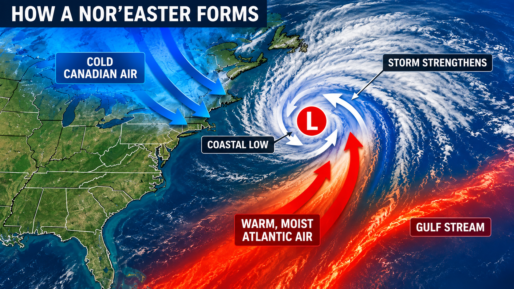
What is a nor’easter?
A nor’easter is a powerful low-pressure system that affects the East Coast of North America, especially the Mid-Atlantic and New England. The name comes from the persistent northeasterly winds that commonly blow from the ocean toward the coast as the storm approaches. Although the term is often associated with snow, a nor’easter is defined by its circulation and track, not by the type of precipitation it produces.
Nor’easters can occur at any time of year, but they are most common and often most intense from September through April. Depending on the storm track and the temperature profile of the atmosphere, the same system can produce heavy snow inland, cold rain near the coast and a mixture of snow, sleet and freezing rain in between.
How does a nor’easter form?
The East Coast provides an unusually favorable environment for strong coastal storms. Cold continental air can move south and east from Canada while warmer, moisture-rich air flows northward over the western Atlantic. Offshore, the Gulf Stream maintains a ribbon of comparatively warm water. The sharp contrast between cold air over land and warmer air over the ocean helps create a zone where atmospheric pressure can fall and a coastal low can develop.
The jet stream is another essential ingredient. A favorable bend or disturbance in the upper-level flow can encourage air to rise and remove mass from the atmospheric column. Surface pressure then falls, the circulation strengthens and additional Atlantic moisture is drawn into the storm. As the low moves northeastward, the contrast between air masses can continue supplying energy.
Not every coastal low becomes a major nor’easter. The exact position of the jet stream, the strength of the temperature contrast, the availability of moisture and the storm’s distance from the coast all influence its development. Small changes in track can separate a historic snowstorm from a mainly rain event or keep the strongest impacts offshore.
Why can nor’easters become so powerful?
Some nor’easters intensify rapidly through a process commonly called bombogenesis. NOAA uses that term for the rapid strengthening of a midlatitude cyclone over a 24-hour period, measured by a significant drop in central pressure. A rapidly deepening storm can produce a tight pressure gradient, which leads to powerful winds over both land and water.
Those winds can reach hurricane force in gusts, but a nor’easter is not a hurricane. Hurricanes are tropical cyclones that draw their energy primarily from warm ocean water and organized thunderstorms around a warm core. Nor’easters are extratropical cyclones powered largely by contrasts between warm and cold air masses. Their wind field is often much broader than the core of a tropical cyclone.
Snow, rain and the importance of the storm track
A classic heavy-snow track places the surface low close enough to the coast to supply Atlantic moisture while keeping the major cities on the colder northwest side of the circulation. A track farther west can pull warm air inland and change snow to sleet or rain. A track farther east may leave the coast with only light precipitation while the strongest winds and heaviest precipitation remain over the ocean.
Nor’easters can also create narrow bands of intense snowfall. Within those bands, snow can accumulate quickly and visibility can fall sharply. Elsewhere in the same storm, precipitation may be much lighter. This is why snowfall forecasts can change considerably when the projected storm track shifts by only a modest distance.
Major impacts
Heavy snow and blizzard conditions can close roads, halt air and rail travel and isolate communities. Strong, moisture-laden snow may damage trees and power lines, especially when leaves remain on the trees early in the season. Wind can cause additional outages and make recovery difficult.
Along the shoreline, persistent onshore flow can pile water against the coast through several high-tide cycles. The result may be coastal flooding, destructive waves, beach erosion and damage to homes, roads and other infrastructure. These impacts can occur even where little or no snow falls. Inland flooding is also possible when a nor’easter produces prolonged heavy rain.
Historic nor’easters
The Great Blizzard of 1888 paralyzed portions of the Northeast with extreme snowfall, powerful winds and deep drifts. Transportation and communication systems failed across major cities, making it one of the most consequential winter storms in United States history.
The Ash Wednesday Storm of March 1962 lingered along the coast through multiple high-tide cycles. Its prolonged winds and waves produced devastating coastal flooding and erosion from the Mid-Atlantic into New England.
The Blizzard of 1978 brought heavy snow and severe wind to the Northeast, stranding motorists and shutting down transportation. Coastal Massachusetts also experienced destructive flooding and waves.
The Perfect Storm of 1991 developed from an unusual interaction among a strong extratropical low, a cold front and the remnants of Hurricane Grace. It generated enormous waves over the North Atlantic and caused extensive coastal damage.
The March 1993 Superstorm affected an enormous portion of the eastern United States. It produced heavy snow from the southern Appalachians through the Northeast, severe weather in Florida, strong winds and coastal flooding. NOAA reports that more than 270 people died during the event.
In March 2018, four nor’easters affected the eastern United States in less than three weeks. The sequence demonstrated how repeated coastal storms can compound power, travel, flooding and erosion problems even when each storm follows a different track.
The forecast challenge
Nor’easters are closely monitored because their impacts depend on details that may remain uncertain until relatively near the event. Forecasters evaluate the evolving jet stream, coastal low development, atmospheric temperatures and the position of precipitation bands. Readers should follow the latest National Weather Service forecasts and local warnings rather than relying on an early snowfall map or a single model projection.