What Is the Polar Vortex, and What Can It Mean for North American Weather?
Prepared with guidance from more than 30 years of professional television meteorology and weather-communication experience.
The polar vortex is a normal part of the winter atmosphere, not a single storm. Its strength and position can help shape cold outbreaks, the jet stream and periods of disruptive winter weather across North America.
A permanent feature of the polar atmosphere
The polar vortex is a broad circulation of low pressure and cold air that surrounds each of Earth’s poles. It is not a newly discovered phenomenon, and it does not suddenly appear whenever a cold wave reaches the United States or Canada. The circulation exists throughout the year, generally becoming stronger during winter and weaker during summer.
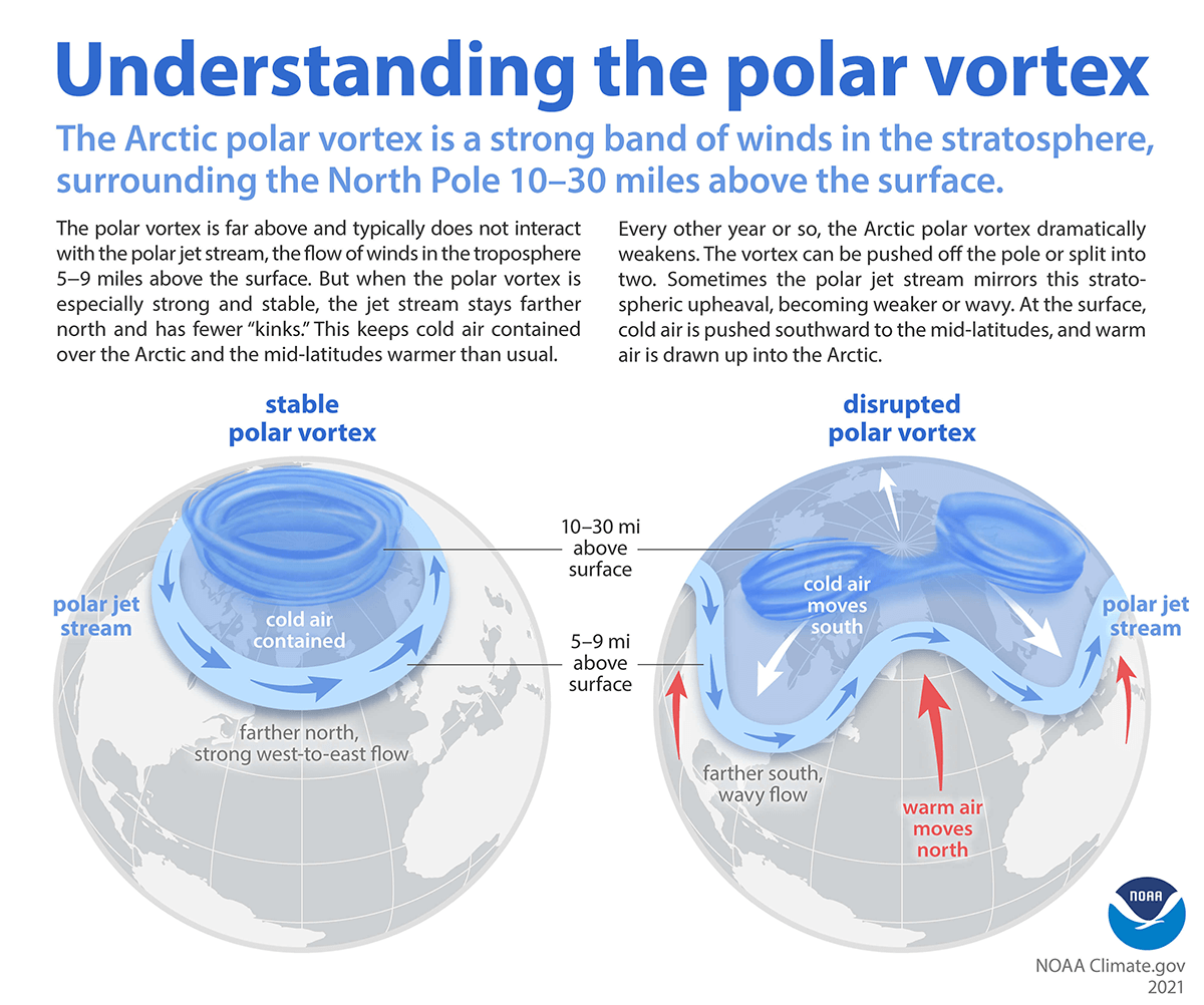
Meteorologists commonly use the term for the stratospheric polar vortex, a ring of strong winds located roughly 10 to 30 miles above the Arctic. Those winds circle from west to east and help isolate a pool of very cold air over the polar region.
This feature should not be confused with the polar jet stream. The jet stream is much lower, generally within the troposphere where most day-to-day weather occurs. It forms near the boundary between colder polar air and warmer air farther south. The stratospheric vortex and the lower jet stream are different features, but changes high in the atmosphere can sometimes influence the pattern below.
Strong does not necessarily mean colder for the United States
A strong, compact and stable polar vortex tends to keep its coldest stratospheric air concentrated near the Arctic. The lower polar jet stream often remains comparatively fast and west-to-east, limiting the ability of deep lobes of Arctic air to push far south. Under that pattern, parts of the middle latitudes can experience relatively mild conditions even while the Arctic remains extremely cold.
When the vortex weakens, stretches, shifts away from the pole or divides into separate circulations, the outcome can be different. The jet stream below may become more amplified, with larger northward ridges and southward troughs. A deep trough can open a path for Arctic air to move into Canada and the United States.
This is why a weakened or disrupted vortex can be associated with severe cold in the middle latitudes. The cold air is not created by the disruption. Instead, the atmospheric pattern allows air that was already present in the Arctic to move southward.
Sudden stratospheric warming
One of the most closely watched disruptions is a sudden stratospheric warming. Large atmospheric waves can travel upward from the troposphere and disturb the stratospheric circulation. Temperatures high above the Arctic can rise dramatically over a short period while the west-to-east winds of the polar vortex slow substantially. In a major event, those winds can temporarily reverse direction.
A sudden stratospheric warming does not mean that surface temperatures immediately become warmer. It describes rapid warming in the stratosphere. The surface response, when one occurs, can take days or several weeks to develop. The vortex may wobble, move away from the pole or split, while the lower jet stream becomes more irregular.
The effects are not automatic. Some disruptions produce a strong response in North American weather, while others have limited influence or direct the coldest air toward Europe or Asia. The background pattern over the Pacific and Atlantic, snow cover, ocean temperatures and other atmospheric oscillations can all affect where ridges and troughs develop.
What it can mean across North America
For Canada and the United States, an amplified winter pattern can bring repeated surges of Arctic air. The northern Plains, Upper Midwest and central Canada often feel the first and most severe temperature drops, but a favorable alignment can carry freezing air into the southern Plains, Southeast and occasionally Florida.
The impacts extend beyond a low thermometer reading. Strong wind combined with Arctic air can produce dangerous wind chills, increasing the risk of frostbite and hypothermia. Prolonged cold can strain electrical and natural-gas systems, freeze water pipes, disrupt transportation and threaten livestock and sensitive crops. Regions unaccustomed to sustained freezes can be particularly vulnerable.
A southward dip in the jet stream can also help organize winter storms. Snow and ice may develop where cold air meets moist air returning from the Gulf of Mexico, the Pacific or the Atlantic. The location of that boundary is critical. One region may experience extreme cold with little snow, while another receives heavy snow, sleet, freezing rain or cold rain.
The East can experience a period of stormy weather when a trough settles over central or eastern North America and upper-level disturbances move through it. On the West Coast, the same broad pattern can produce a ridge that redirects Pacific storms northward, although the exact placement changes from event to event. No single polar-vortex configuration guarantees a particular local result.
Not every cold wave is a polar-vortex event
The phrase is sometimes used as a dramatic label for almost any spell of winter cold. That can be misleading. Cold air can reach the United States through ordinary changes in the jet stream without a major disruption of the stratospheric vortex. Surface high pressure, snow cover, storm tracks and regional wind patterns often play a more immediate role in the temperatures people experience.
The polar vortex is also not a hurricane-like storm descending from the pole. It is an enormous circulation high in the atmosphere. Forecast maps showing a lobe of low pressure over North America represent part of a much larger hemispheric pattern, not a compact surface cyclone.
How forecasters monitor it
Meteorologists examine stratospheric temperatures, pressure patterns and winds, particularly the winds near the 10-millibar level high above the Arctic. They also monitor whether the vortex is centered over the pole, displaced or divided into separate lobes.
Forecast models can identify the potential for a stratospheric disruption well in advance, but translating that signal into a local forecast remains difficult. A disruption can increase the odds of a colder pattern without identifying which city will be coldest or exactly when the change will arrive.
For practical decisions, the local forecast remains more important than a headline about the polar vortex. The National Weather Service forecast for a specific location incorporates the jet stream, surface pressure systems, snow and ice potential, wind and the timing of individual cold fronts.
The useful takeaway
The polar vortex is a normal and persistent part of the atmosphere. When it is strong and well organized, the coldest air often remains closer to the Arctic. When it becomes disturbed, the odds can increase that the jet stream will turn wavier and send Arctic air into portions of North America.
That connection is real, but it is not a simple switch. A disrupted vortex does not guarantee extreme cold in every part of the continent, and it does not provide a precise local forecast by itself. It is best understood as one important influence on the larger winter pattern.